

We’re about to enter the heart of the Atlantic hurricane season
source link: https://arstechnica.com/science/2022/08/the-atlantic-hurricane-season-is-off-to-a-slow-start-but-that-probably-wont-last/
Go to the source link to view the article. You can view the picture content, updated content and better typesetting reading experience. If the link is broken, please click the button below to view the snapshot at that time.

Storm time —
We’re about to enter the heart of the Atlantic hurricane season
About 90 percent of the Atlantic's tropical activity comes after August 1.
Eric Berger - 8/1/2022, 2:03 PM
Take a deep breath, everyone—the Atlantic hurricane season is one-third over. And there's some good news to report.
To date, the Atlantic has produced three named storms, Alex, Bonnie, and Colin. Historically, three named storms before the beginning of August would represent a busier-than-usual start to a season that officially lasts six months, from June 1 to November 30. But a simple storm count is a superficial measure of activity.
None of these storms has exceeded tropical storm strength, and they lasted only about a day. By other more revealing measures, the Atlantic is having a relatively slow start. At the beginning of August, an average year produces nearly nine days on which a tropical storm or hurricane has been active. This year, the number of "named storm days" is just 3.25. And by the measure of "accumulated cyclone energy," which accounts for both storm duration and intensity, the Atlantic basin is only producing about 30 percent of its normal activity.
The last storm to form was Colin, which briefly grazed the Carolinas before dissipating on July 3. If no storm forms by August 3—which seems almost certain at this point—this would be the fifth time in the last three decades that no tropical storm was active between July 3 and August 3.
AdvertisementAll the same, it's probably best not to read too much into this season's slow start. The general pattern so far is in line with expectations. The Atlantic often sees a handful of weaker storms in May or June and then a lull in July. The season doesn't really get going until tropical waves start to roll off of Africa and couple with the sea (tropical waves are not waves in the ocean but rather low-pressure systems in the atmosphere). Once over the Atlantic Ocean, they can develop into tropical systems by using moisture from the sea to produce thunderstorms.
Favorable conditions for the development of these tropical waves, including warm seas, low wind shear, and a lack of Saharan dust, usually don't align for tropical storms and hurricanes until August. This year, it looks like we'll see a quiet period for another week or even longer as dust persists and seas in key areas have been somewhat slower to warm.
But don't take too much comfort from that. About 90 percent of the Atlantic's tropical activity, and nearly all of its hurricanes, come after August 1, so we'll have to wait to see what comes later this summer and into the fall months.
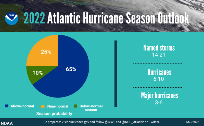
Previously, NOAA predicted an above-normal season due to a persistent La Niña in the Pacific Ocean, which decreases wind shear in the Atlantic. This prediction was in line with other forecasters who also have said they anticipate a very busy year for the Atlantic tropics. NOAA will update its seasonal forecast on Thursday.
Listing image by GSO Images/Getty
Recommend
About Joyk
Aggregate valuable and interesting links.
Joyk means Joy of geeK