

Using Google Maps in a Jetpack Compose app - Part 2!
source link: https://johnoreilly.dev/posts/jetpack-compose-google-maps-part2/
Go to the source link to view the article. You can view the picture content, updated content and better typesetting reading experience. If the link is broken, please click the button below to view the snapshot at that time.

Using Google Maps in a Jetpack Compose app - Part 2!
04 Feb 2022
Share on:
In a previous article back in July of 2020 I outlined how Google
Maps support could be added to a Jetpack Compose app based on what was available at that time (using AndroidView). I mentioned in that article that
it “seems like this is something that ultimately will exist as specific Jetpack Compose @Composable” and was very happy to see
following tweet recently about availability of new Maps Compose component.
In this post I’m going to describe how the Galway Bus Kotlin Multiplatform app was
updated to use this component.
The dream is now a reality 🤩 I'm excited to share Maps Compose, a library to help you add a Google Map in Jetpack Compose. Go check it out: https://t.co/WyCQcxwXjG #JetpackCompose #AndroidDev https://t.co/0jR1JQiYfd
— Chris Arriola (@arriolachris) February 3, 2022
Maps Compose
Firstly, as outlined in the Maps Compose github page, the following dependencies
need to be added to the app’s build.gradle.kts file (based on current versions at ths time).
implementation("com.google.maps.android:maps-compose:1.0.0")
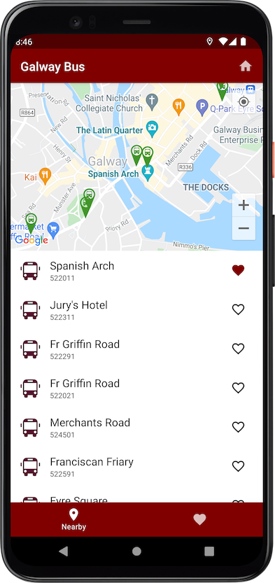
implementation("com.google.android.gms:play-services-maps:18.0.2")As shown in the screenshot below the app shows the bus stops near to a particular location, both as markers on the map and also in a list as shown below.
We need to be able to drive the map’s camera position from location, a StateFlow in the view model (the updating of which also in turn triggers
querying for list of bus stops close to that location and updating associated state). This can be set in a number of ways:
- from the device’s location on startup
- when the user presses the “home” button in the app bar (centering in particular location in the city)
- as the user pans/changes location on the map
We can manage the setting and observing of changes to that camera position using the component’s CameraPositionState.
val currentLocation by viewModel.location.collectAsState()

val cameraPositionState = rememberCameraPositionState {
    position = CameraPosition.fromLatLngZoom(LatLng(currentLocation.latitude, currentLocation.longitude), 15f)
}
Now we need to manage the interdependent relationship between the location state in the view model and the map’s camera position. Changing
one updates the other and vice versa. The way we can do this is using Compose’s snapshotFlow as shown below. Note that
I had initially modelled that first dependency using derivedStateOf but ran in to some snapshot related state issues when
used with the subsequent snapshotFlow (hope to get chance to dig a bit deeper in to that and figure out why).
snapshotFlow { currentLocation }
    .collect {
        cameraPositionState.position = CameraPosition.fromLatLngZoom(LatLng(currentLocation.latitude, currentLocation.longitude), 15f)
    }

snapshotFlow { cameraPositionState.position }
    .collect {
        viewModel.setLocation(Location(it.target.latitude, it.target.longitude))
    }
Lastly this is how we setup GoogleMap, passing in the cameraPositionState from above and also other
initialisation properties along with adding Markers for each of the bus stops.
val mapProperties by remember { mutableStateOf(MapProperties(isMyLocationEnabled = true)) }
val uiSettings by remember { mutableStateOf(MapUiSettings(myLocationButtonEnabled = true)) }

GoogleMap(
    modifier = modifier,
    cameraPositionState = cameraPositionState,
    properties = mapProperties,
    uiSettings = uiSettings
) {
    stops.forEach { stop ->
        val busStopLocation = LatLng(stop.latitude, stop.longitude)
        val icon = bitmapDescriptorFromVector(context, R.drawable.ic_stop, R.color.mapMarkerGreen)
        Marker(position = busStopLocation, title = stop.shortName, icon = icon)
    }
}
A different map in this application shows the live position of buses for a particular route. This uses GoogleMap as
above but also needs to set bounds of map based on the positions of those buses. This can be done using something like the
following.
val builder = LatLngBounds.Builder()
busInfoList.forEach { bus ->
    val busLocation = LatLng(bus.latitude, bus.longitude)
    builder.include(busLocation)
}

cameraPositionState.move(CameraUpdateFactory.newLatLngBounds(builder.build(), 64))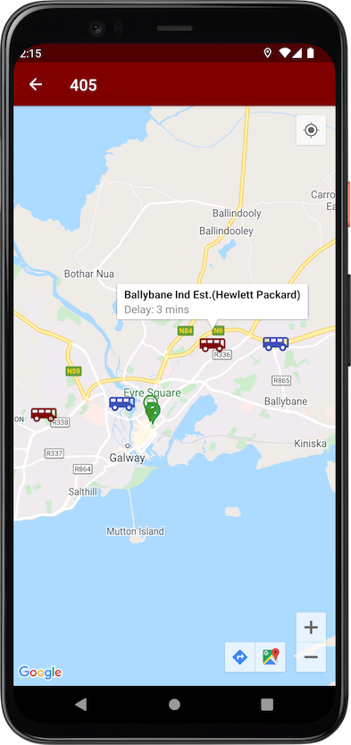
The above changes have been pushed to the GalwayBus repo and new version published to Play Store.
Note also that Maps Compose’s github repo also includes a sample app
that demonstrates other capabilties provided by the library.
Featured in Kotlin Weekly Issue #288
Related tweet
Using Google Maps in a Jetpack Compose app - Part 2! https://t.co/afCUQZ0pbA
Wrote a short follow up article on initial exploration of using the new "Maps Compose" library to add Google Maps support to a #JetpackCompose app. https://t.co/ja2o9a3vsH pic.twitter.com/sDH3V8fyRO— John O'Reilly (@joreilly) February 5, 2022
Recommend
-
6
Welcome back to the second article in my series about migrating design systems to Jetpack Compose, where I talk about our experiences at
-
9
Android Jetpack Compose: An easy way to RecyclerView (Part I) If you're new to Jetpack Compose and looking at all the cool UI screens and animations around the...
-
5
Android Jetpack Compose: Styles and Themes (Part II) If you're new to Jetpack Compose and looking at all the cool UI screens and animations around the internet...
-
8
Android Jetpack Compose: Navigating to a Detail View (Part III) If you're new to Jetpack Compose and looking at all the cool UI screens and animations around th...
-
19
Maps Compose Description This repository contains Jetpack Compose...
-
11
#Android #Jetpack #ComposeLet's learn Android Jetpack Compose together! - Part 3 - Pagination!8...
-
7
Introduction This is going to be a 3 part series where I show how to set up a dark mode with jetpack compose. The three parts are: 1) Setting up dark mode for single view 2) Sett...
-
13
Adding animations to Google Maps in Jetpack ComposeCommunity PostYou might have already seen Sinasa...
-
8
Performance With Jetpack Compose — Part 1Published in
-
5
Engineering
About Joyk
Aggregate valuable and interesting links.
Joyk means Joy of geeK