

Access over 181,000 USGS Historical Topographic Maps
source link: https://www.esri.com/arcgis-blog/products/arcgis-living-atlas/mapping/access-over-181000-usgs-historical-topographic-maps/
Go to the source link to view the article. You can view the picture content, updated content and better typesetting reading experience. If the link is broken, please click the button below to view the snapshot at that time.

Access Over 181,000 USGS Historical Topographic Maps
In collaboration with the US Geological Survey (USGS), we recently updated Esri’s online USGS historical topographic map collection with over 1,745 new maps, bringing the total number of maps in our collection to over 181,000 (181,008 to be exact). We also corrected a number of maps that our users reported as having georeferencing or other errors.
These maps are part of the USGS Historical Topographic Map Collection (HTMC) which includes all the historical topographic quadrangle maps (quads) that had been printed since the USGS topographic mapping program was initiated in 1879. More about this below.
Esri’s USGS historical topographic map collection contains historical quads (excluding orthophoto quads) dating from 1884 to 2006 with scales ranging from 1:10,000 to 1:250,000. The scanned maps can be used in ArcGIS Pro, ArcGIS Online, and ArcGIS Enterprise. They can also be downloaded as georeferenced TIFs for use in other applications.
The Historical Topo Map Explorer App
We make it easy for you to explore and download these maps, or quickly create an ArcGIS Online map, using our Historical Topo Map Explorer app. Originally launched in 2014, we recently updated the app with a new look and new features, like overlaying the historical maps on a satellite image or 3D hillshade and adding labels for current geographic features (figure 1). The app provides a visual interface to search and explore the historical maps by geographic extent, publication year, and map scale. Learn more about the app in this blog post by John Nelson and friends. You can also access the app from ArcGIS online here.
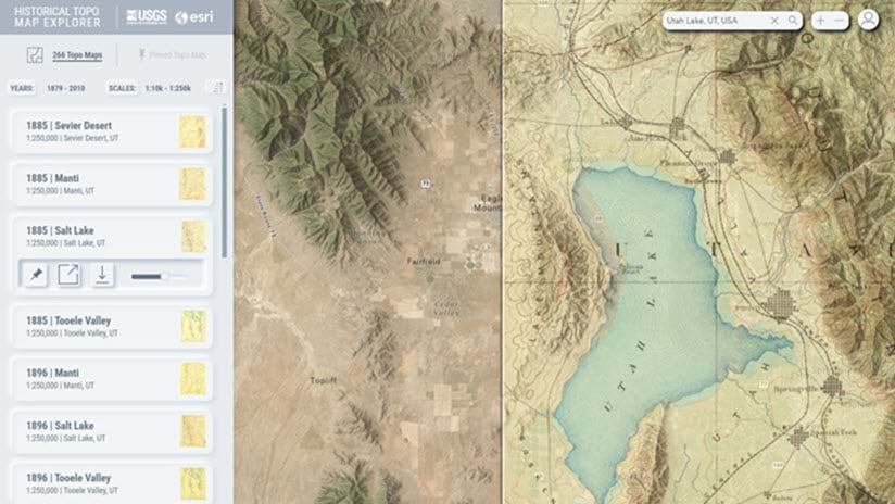
ArcGIS Living Atlas Historical Topo Map Explorer app
Figure 1. The recently updated Historical Topo Map Explorer app helps you visually explore and access over 181,000 historical scanned USGS topo maps, and you can add terrain, satellite imagery, and labels to the display.
More about the USGS Historical Topographic Map Collection
As mentioned above, the historical maps in Esri’s collection are part of the USGS HTMC (click here to learn more). This collection is the product of the USGS Historical Quadrangle Scanning Project which was launched in 2011 to provide a digital archive of the irreplaceable collection of topographic maps in the USGS Reston Map Library. The HTMC includes all scales and all editions of the topographic maps published by the USGS from 1884, when “John Wesley Powell persuaded the U.S. Congress to authorize the U.S. Geological Survey (USGS) to begin systematic topographic mapping of the United States” (see this source) thus initiating the US topographic mapping program, and 2006, when “the final maps created using traditional cartographic methods and lithographic printing processes were published (see this source).”
Regarding the map scales, according to the USGS:
The U.S. Geological Survey (USGS) publishes maps at various scales. The scale used for most U.S. topographic mapping is 1:24,000. USGS maps at this scale cover an area measuring 7.5 minutes of latitude and 7.5 minutes of longitude and are commonly called 7.5-minute quadrangle maps. Map coverage for most of the United States has been completed at this scale, except for Puerto Rico, which is mapped at 1:20,000 and 1:30,000, and for a few States that have been mapped at 1:25,000. Most of Alaska has been mapped at 1:63,360, with some populated areas also mapped at 1:24,000 and 1:25,000.
Previously available only as printed lithographic copies, the historical maps were scanned “as is” to create high-resolution images that capture the content and condition of each map sheet. All maps were georeferenced, and map metadata was captured as part of the process.
For the Esri collection, the scanned maps were published as an ArcGIS Online image service that can be viewed on the web and allows users to download individual scanned images.
For maps that are not in the Esri collection and maps after 2006, the USGS National Map Downloader app is the primary portal for finding and downloading maps and other data products of the USGS National Geospatial Program. The topoView app provides a visual overview of the HTMC and serves maps in additional formats. You can also create on demand maps using the topoBuilder app. To learn more about these USGS tools and resources, click here.
To learn more about the history of topographic mapping at the USGS, read this ArcNews article and this USGS publication. To learn more about the symbols used on historical USGS topo maps, click here.
Using the Historical Maps in Your Work
Want to learn more about how you can use these maps in your maps and projects? Here are a few examples.
- Bern Szukalski wrote this blog post explaining how to use the topo maps in the Esri collection as your ArcGIS Online basemap.
Although the following blog posts use the vintage explorer app, you can easily use the updated app to achieve the same results.
- I wrote this blog post about “Using Historical USGS Topographic Maps in ArcGIS Pro”.
- Check out this blog post from John Nelson about adding a 3D effect to the scanned maps.
- John also showed us how to highlight an area of interest on a historical topo quad in this blog post.
About the author

Aileen Buckley
Dr. Aileen Buckley is a cartographer who’s been at Esri since 2003. She finds and shares best practices for mapping and analysis with ArcGIS, which leads her to publish widely and present world-wide.
Recommend
About Joyk
Aggregate valuable and interesting links.
Joyk means Joy of geeK