

Museums Roadtrip USA
source link: https://wilsonmar.github.io/museums-roadtrip-usa/
Go to the source link to view the article. You can view the picture content, updated content and better typesetting reading experience. If the link is broken, please click the button below to view the snapshot at that time.
Visual, architectural, and culinary art in every state and major city, mapped by Machine Learning
This page lists where one can visit, see, and eat at the most important cultural artifacts in America. I created this page as “bucket list” so that even if I can’t visit each one and perhaps enjoy on-site, I can still visit their web pages. Someday soon everyone can see treasures from anywhere using VR (Virtual Reality) glasses providing 360-degree views in High Definition.
Do you have a roadtrip map or story? Please send it to me for posting here.
NOTE: Content here are my personal opinions, and not intended to represent any employer (past or present). “PROTIP:” here highlight information I haven’t seen elsewhere on the internet because it is hard-won, little-know but significant facts based on my personal research and experience.
It’s a large country, so sites here are listed by each state of the union, along natural geography East-to-West:
Journeys on water as she flows toward the Equator:
Journeys Northward on Cattle Drives in the 1880s.
Journeys Westward on land (The Pony Express
BTW, finding where each site is located resulted in a great geography and historical lesson for me.
Extreme corners
Iron Butt motocyle rallies award bonus points for reaching the four corners of the nation:
- NorthEast: Madawaska, ME
- SouthEast: Key West, FL
- SouthWest: San Ysidro, CA
- NorthWest: Blaine, WA
Touching each state
This Google route map was actually used by recent finishers to go around the 48 states in 6 days:
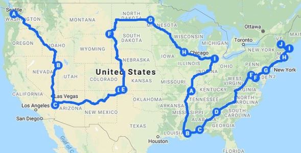
To deter reckless driving among Extreme Road-trippers, the Guinness World Records discontinued listing speed records in 1996. But that didn’t stop the All Fifty States Club website.
Highway Refueling and ReCharging
Notice the US interstate highway numbering system:
The number of Tesla Supercharger locations jumped to 2,966 in Q2 2021 from 1,587 at Q1 2019:

A map of stations offering Ethanol-free premium gasoline (at higher prices) is at pure-gas.org/extensions/map.html. My wife used it to figure out where I should stop along a route from Florida to Montana. It was difficult because we had to figure out where I was on the website’s map. She also had to calculate how much further I could go with remaining gas. Somehow we managed to stay married after that.
National Parks
America’s greatest treasure is the 63 national parks managed by the U.S. National Park Service.

The map above is missing White Sands National Park (New Mexico), Indiana Dunes, and Gateway Arch (St. Louis).
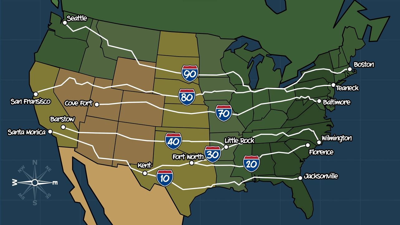
One couple visited the most significant parks in this order:


The above route through major landmarks in the lower 48 states was optimized for least driving time across 6,813 miles, using Google Maps API driven by Machine Learning algorithms run in a Python Jupyter Notebook as described by Randal S. Olson.
CAUTION: as COVID lockdowns relax, reservations are at all-time highs at recreation.gov/, KOA, ReserveAmerica.com, and state camping sites.
Many “Western” movies were filmed in iconic “Mighty 5” parks below Salt Lake City in Utah: Las Vegas from the South and Denver from the North

:
- Bryce Canyon VIDEO
- Capital Reef
- Arches
- Canyonlands
Civil War Confedrates
When the Civil War ended in 1865, The Confederacy included the 11 Southern states of Texas, Arkansas, Louisiana, Tennessee, Mississippi, Alabama, Georgia, Florida, South Carolina, North Carolina, and Virginia.

The 5 “Border States” were Maryland, Delaware, West Virginia, Kentucky, and Missouri.
States in white (Oklahoma) did not fight for either side. Idaho volunteers did not fight against the Confederacy. Areas in Arizona and New Mexico were claimed by both sides.
Down the Atlantic Eastern Seaboard
This is where the United States of America began as colonies of England.
Freedom Ride
The planned route of the courageous Freedom Ride May 1961 through the “Jim Crow” South to test a Supreme Court ruling against “whites-only” restrooms and lunch counters at bus stations:

The Woolworth lunch counter in downtown Greensboro, NC is now a museum.
The ride stopped on May 14 in Anniston, Alabama where the bus was burnt by segregationists.
Maine
New Hampshire
Massachusettes
Boston:
Cambridge (North of Boston):
- Harvard University Art Museums, Cambridge
- Peabody Museum of Archaeology and Ethnology at Harvard University, Cambridge
- Fogg Art Museum
- MIT Museum
- Arthur M. Sackler Museum
- Rose Art Museum at Brandeis University, Waltham
- Henry Wadsworth Longfellow House, Cambridge, Massachusetts
Western Mass Turnpike 90:
- Edith Wharton's The Mount, Lenox
- Museum of Bad Art, Dedham
- McMullen Museum of Art at Boston College, Chestnut Hill
- Davis Museum and Cultural Center at Wellesley College, in Wellesley, MA
- Danforth Museum of Art, Framingham
- Worcester Art Museum
- Old Sturbridge Village
- Norman Rockwell Museum, Stockbridge
- Mount Holyoke College Art Museum, South Hadley
- Berkshire Museum, Pittsfield
- Herman Melville's Arrowhead, Pittsfield
- The Springfield Museums at the Quadrangle
- Dr. Seuss Memorial, Springfield
- Site of Thoreau's Cabin, Walden Pond, Concord
- Wayside (home of Nathaniel Hawthorne, Louisa May Alcott, and Margaret Sidney), Concord
- Ralph Waldo Emerson Home, Concord
- Louisa May Alcott's Orchard House, Concord
Northward Mass up 95:
SouthEast of Boston on 3 to the tip:
Western Mass up 91:
Southern Mass:
Rhode Island
Connecticut
New Jersey
New York
New York City (Manhattan)
New York City (Brooklyn)
DUMBO = Down Under the Manhattan Bridge Overpass is home to 25% of New York based tech firms, including Etsy. [tour]
- Walk the Brooklyn Bridge
- River Cafe (Jackets required of men)
- Brooklyn Museum of Art
- Rotunda Gallery
Pennsylvania
Philadelphia:
Pittsburgh:
Delaware
Maryland
Washington DC
- Dumbarton Oaks Collection
- Freer Gallery of Art
- National Air and Space Museum
- National Archives, 700 Pennsylvania Ave. 202-357-5000 See the US Constitution, Bill of Rights and the Declaration of Independence. But the Emancipation Proclamation is open to the public just 4 days a year around MLK Holiday Jan. 13-16 Friday-Monday 10 a.m.-5:30 p.m.
- The Smithsonian Institution: The Freer Gallery of Art and The Arthur M. Sackler Gallery
- Sackler/Freer Galleries
- Art Museum of the Americas
- Corcoran Gallery of Art
- Dimock Gallery at George Washington University
- Dumbarton Oaks Research Library and Collection
- Hillwood Museum and Gardens
- Hirshhorn Museum and Sculpture Garden
- Howard University Gallery of Art
- Kreeger Museum
- U.S. National Gallery of Art
- National Museum of African Art
- Smithsonian American Art Museum
- National Museum of Women in the Arts
- National Portrait Gallery
- National Statuary Hall
- Phillips Collection 1600 21st Street, NW 20009 Closed Mondays
- Smithsonian Institution
- Textile Museum
- U.S. Capital Art Collection
- U.S. Navy Art Collection
- US Holocost Memorial Museum 10-5:30 every day, but timed passes are necessary for visiting the permanent exhibit (20 each day from tickets.com for $1.75)
- White House, 1900 Pennsylvania Avenue
West Virginia
Virginia
Williamsburg:
- Muscarelle Museum of Art at the College of William and Mary
- Abby Aldrich
- Rockefeller Folk Art Collection
- Colonial Williamsburg Villege
North Carolina
South Carolina
Georgia
Atlanta:
Florida
St. Petersberg Northwest on 75 up the Gulf coast
South down the East coast
Miami:
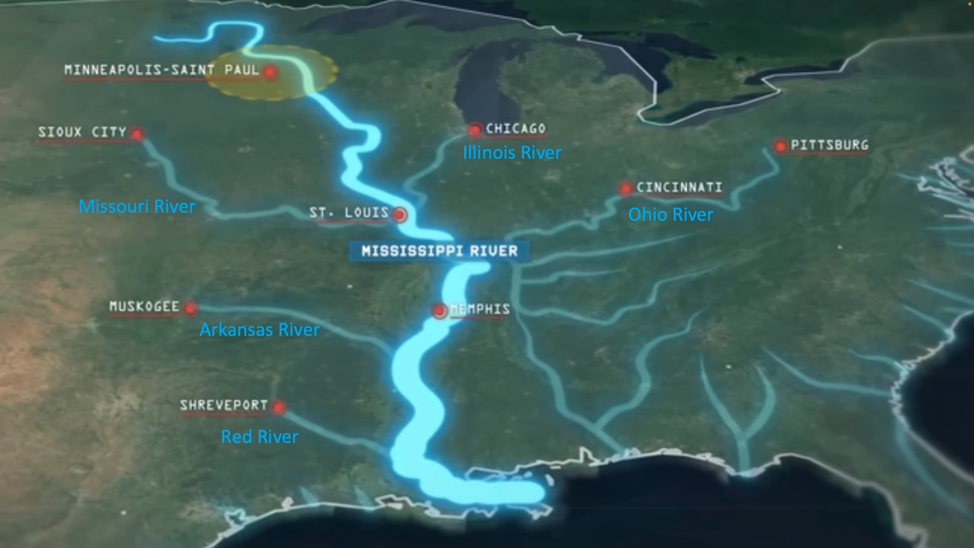
Down the Mississippi River

VIDEO: “It’s inevitable that the US emerged as a global superpower”: the Missisippi is the longest navigable river in the world, enabling inland cities to be oceanic ports serving world markets by boat (10-39X cheaper than by road).
</a>
Viking River Cruises has an 8 day “America Heartland” cruise between St. Louis and to St. Paul (waterfalls at the head of the Mississipi):

Cruise on a riverboat between New Orleans and Memphis, with stops in the Vicksburg battlegrounds.
on Viking or the “American Countess”.
Cruise from Chicago to St. Louis down the Illinois River.
Illinois
Chicago:
Missouri
Kansas City:
St. Louis:
Tennessee
Nashville:
Memphis:
Arkansas
Mississippi
Louisiana
Alabama
Journeys Northward on Cattle Drives
The TV series “1883” is about one of the cattle drives that brought Texas back from economic collapse after the end of the Civil War in 1865. The drive went from Fort Worth North toward Montana and Portland. Although a fictional story, the script mentions real locations: Doan’s Store Red River Crossing, established 1878 along the Western Trail to Dodge City, Kansas where trains carried cattle East.
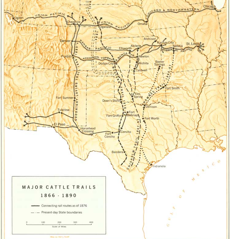
In 1881 the Doan’s Cross reached a peak of 301,000 cattle driven by to Kansas shipping points. This was before the “Chisolm Trail”.
In 1884 an annual picnic, celebrating the cattle drives and cowboy tradition, began near Doan’s Store.
In 1885 long cattle drives was eliminated by both the construction of railroads across north Texas and the fencing of the West using newly invented barbed wire.
The TV series “Lonesome Dove”, is set in late 1870s. Just like the “1883” TV series, it is also about cowboys seeking to drive cattle North to settle along Montana’s Yellowstone River. Several other movies have characters doing the same.
Journeys Westward on land
The Western frontier, even today, is separated by the 100th Meridian line of Longitude near (from the South) San Antonio, Fort Worth, Oklahoma City, Wichita, Omaha, Souix Falls, and Fargo. VIDEO (using NASA’s BlackMarble satellite images of the nigh sky worldwide):

“that line separates wetter climate to the East and the drier air in the West blocked by the Rocky Mountains”
“Go West, young Man, and grow up with the country!” is the advice widely (but wrongly) attributed to New York Tribune Publisher Horace Greeley, who visited the West only once.
The Pony Express
Pony Express riders (who include “Calamity Jane”) delivered mail less than 2 years: from April 3, 1860 to October 24, 1861. Their 1,900-mile (3,100 km) route went along 184 stations (10 miles apart) from St. Joseph, Missouri on the Missouri River to San Francisco, California:

Map by William Henry Jackson, American artist. Text: Howard Roscoe Driggs. Scan: US Library of Congress. Photo image obtained/rendered by Gwillhickers. Restoration by Crisco 1492, Public Domain.
Westward from Vermont to Kentucky
Vermont
Upstate New York
Albany/Rochester:
Adirondacks
Buffalo:
Michigan
Detroit
Ohio
Cincinnati:
- Cincinnati Art Museum
- Museum Center of Union Terminal
- American Neon Sign Museum</a>
- Creation Museum (is closest to the Cincinnati airport)
- Ark Encounter (44 miles South in Kentucky from the Creation Museum)
Cleveland:
Indiana
Indianapolis:
Kentucky
Down the Pacific West Coast
- The Coast Starlight line on Amtrak has coastal portions between Seattle and Portland, and along the middle of California.
Alaska
NOTE: Driving from Alaska to Washington state requires travel through Canada.
Washington
Spokane:
Seattle:
Oregon
California
San Francisco Bay:
San Jose:
Santa Barbara (Central Coast):
West Side, Los Angeles:
Downtown Los Angeles:
East Los Angeles:
South Bay, Long Beach:
Orange County:
Inland Empire:
San Diego:
Hawaii
Just so we include all the states:
Westward through Northern states
Going from New York City to Seattle takes 2,852-miles on Interstates 80 and 90, crossing 11 states.
Northern Rail
Amtrak’s Empire Builder train between Chicago to Seattle and Portland takes 46 hours.

Amtrak’s California Zephyr (named after the Greek god of the Western wind). VIDEO: from Chicago to Emeryville (San Franciso) – 2 nights through 7 states: Naperville, Galesburg, Omaha, Denver (a one hour stop) over the mountains to Grand Junction, Reno, Truckee, Salt Lake City. With no wi-fi between stations.
Lewis and Clark Trail Westward Ho
The Lewis and Clark Expedition of 1804 to 1806 is an 8,000-mile trip to the Pacific (Portland, Oregon) returned with maps and scientific specimens for President Thomas Jefferson.
The Lewis and Clark Trail today is a set of hiking trails. “Wm Clark” carved “July 25, 1806” on “Pompey’s Pillar” in Billings, Montana.

The “Corps of Discovery” emboldened wagon trains traveling Westward through Northern United States.
Oregon Trail to the Pacific
The Oregon Trail was established during the 1830s by mountain men in their fur trade, before motorized transportation. It favors valleys to minimize going over mountains:

The trail begins from St. Louis and Independence, Missouri through Kansas and Nebraska to Fort Laramie, Wyoming. It then goes through Boise, Idaho to Portland, Oregon. The map of it in 1907:

Kansas
Iowa
Wisconsin
Milwaukee:
Minnesota
Duluth (North coast of Lake Superior)
Minneapolis:
St. Paul:
Nebraska
South Dakota
North Dakota
Montana
Idaho
Westward through the Southwest
VIDEO: Route 66 was one of the original highways within the U.S. starting in 1924. Thus its colloqual name the “Mother Road”. It served as a military transport corridor during WWII. During post-war years, motels, diners, and gas stations along Route 66 became popular vacaction destinations. From 1956, interstates built provide a road without the need to slow down through towns.

Route 66 begins in Michigan Avene in Chicago. Eat at Lou Mitchell’s diner The route goes to St. Louis, Missouri, then through smaller road-side towns on the way to Tulsa and Oklahoma City, Amarillo TX, Alberquque New Mexico, then over mountains to Flagstaff AZ before ending on the Santa Monica pier in Los Angeles, California.
Chisolm Trail
The Chisolm Trail was used between 1867-1884 to drive cows to market from various cowtowns in Texas through Oklahoma Indian Territory to Abilene and other railheads in Kansas. The Lonesome Dove TV series depicts that time.
Since Illinos and Missouri are already listed in our Mississippi route, we begin from Oklahoma and take a long detour North to avoid too much desert along the way.
Oklahoma
Texas
Dallas:
Austin:
Houston:
New Mexico
Santa Fe:
Taos:
Colorado
Denver:
Wyoming
(Southern Idaho)
Utah
Arizona
Nevada
- Nevada Museum of Art, Reno
- Harrah's Auto Collection, Reno
All the sights
In addition to “museums”, also included here are grand natural sights:
- historic landmark hotels
- Restaurants with unique interiors/art
- Cool Architecture - churches
- National Monuments
-
US Presidential libraries, museums, and birth places
- Iconic movie locations of note [map]
- Caverns
- Factory tours
-
Experiences sold by Viator, The ONE Thing You Must Do In Each U.S. State
- Amusement parks
- State Fairs
- Tripadvisor Excellence award winners
- Most scenic restaurants according to OpenTable, Zagat, Michelin
Technical Footnote
This rather large list was originally created to be intentionally large in order to test how well the system handles a large file (how quickly it can download and display).
This is an upgrade of my terrible Roadtrips to visit museums across the USA from 2005.
Next, I’d like to display a Google map of coordinates from a public Google spreadsheet like Jessica Lord’s hack-spots site implemented from a github repo which uses the sheetsee.js and Mapbox libraries.
“I haven’t been everywhere, but it’s on my list.” – Susan Sontag
Others must know: please click to share:
Museums Roadtrip USA was published on December 30, 2022.
Recommend
About Joyk
Aggregate valuable and interesting links.
Joyk means Joy of geeK