

Obtain Nearest Address to a Longitude-latitude Poi - DZone Integration
source link: https://dzone.com/articles/obtain-nearest-address-to-a-longitude-latitude-poi
Go to the source link to view the article. You can view the picture content, updated content and better typesetting reading experience. If the link is broken, please click the button below to view the snapshot at that time.
Obtain Nearest Address to a Longitude-latitude Point
Want to allow your users to obtain addresses for selected longitude-latitude points on your in-app map? Read on to find out how.
In the mobile Internet era, people are increasingly using mobile apps for a variety of different purposes, such as buying products online, hailing taxis, and much more. When using such an app, a user usually needs to manually enter their address for package delivery or search for an appropriate pick-up and drop-off location when they hail a taxi, which can be inconvenient.
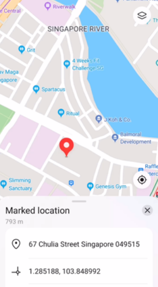
To improve user experience, many apps nowadays allow users to select a point on the map and then use the selected point as the location, for example, for package delivery or getting on or off a taxi. Each location has a longitude-latitude coordinate that pinpoints its position precisely on the map. However, longitude-latitude coordinates are simply a string of numbers and provide little information to the average user. It would therefore be useful if there was a tool which an app can use to convert longitude-latitude coordinates into human-readable addresses.
Fortunately, the reverse geocoding function in HMS Core Location Kit can obtain the nearest address to a selected point on the map based on the longitude and latitude of the point. Reverse geocoding is the process of converting a location as described by geographic coordinates (longitude and latitude) to a human-readable address or place name, which is much more useful information for users. It permits the identification of nearby street addresses, places, and subdivisions such as neighbourhoods, counties, states, and countries.
Generally, the reverse geocoding function can be used to obtain the nearest address to a device's current location, show the address or place name when a user taps on the map, find the address of a geographic location, and more. For example, with reverse geocoding, an e-commerce app can show users the detailed address of a selected point on the map in the app; a ride-hailing or takeout delivery app can show the detailed address of a point that a user selects by dragging the map in the app or tapping the point on the map in the app so that the user can select the address as the pick-up address or takeout delivery address. An express delivery app can utilize reverse geocoding to show the locations of delivery vehicles based on the passed longitude-latitude coordinates, and intuitively display delivery points and delivery routes to users.
Bolstered by a powerful address parsing capability, this kit's reverse geocoding function can display locations' addresses in accordance with local address formats with an accuracy as high as 90%. In addition, it supports 79 languages and boasts a parsing latency as low as 200 milliseconds.
Demo
The file here is a demo of the reverse geocoding function in this kit.
Preparations
Before getting started with the development, you will need to make some preparations, such as registering as a developer and completing identity verification on the HUAWEI Developers website, creating a project and adding your app to the project in AppGallery Connect, generating a signing certificate fingerprint and configuring it in AppGallery Connect, and integrating the Location SDK into your app.
You can refer to the official website to learn how to perform the relevant preparations. I won't be describing it in detail in this article.
Development Procedure
After making relevant preparations, you can perform the steps below to use the reverse geocoding service in your app. Before using the service, ensure you have installed HMS Core (APK) on your device.
1. Create a geocoding service client.
In order to call geocoding APIs, you first need to create a GeocoderService instance in the onClick() method of GeocoderActivity in your project. The sample code is as follows:
Locale locale = new Locale("zh", "CN");
GeocoderService geocoderService = LocationServices.getGeocoderService(GeocoderActivity.this, locale);
2. Obtain the reverse geocoding information.
To empower your app to obtain the reverse geocoding information, you need to call the getFromLocation() method of the GeocoderService object in your app. This method will return a List<HWLocation> object containing the location information based on the set GetFromLocationRequest object.
a. Set reverse geocoding request parameters.
There are three request parameters in the GetFromLocationRequest object, which indicate the latitude, longitude, and a maximum number of returned results respectively. The sample code is as follows:
// Parameter 1: latitude
// Parameter 2: longitude
// Parameter 3: maximum number of returned results
// Pass valid longitude-latitude coordinates. If the coordinates are invalid, no geographical information will be returned. Outside China, pass longitude-latitude coordinates located outside China and ensure that the coordinates are correct.
GetFromLocationRequest getFromLocationRequest = new GetFromLocationRequest(39.985071, 116.501717, 5);
b. Call the getFromLocation() method to obtain reverse geocoding information.
The obtained reverse geocoding information will be returned in a List<HWLocation> object. You can add listeners using the addOnSuccessListener() and addOnFailureListener() methods, and obtain the task execution result using the onSuccess() and onFailure() methods.
The sample code is as follows:
private void getReverseGeocoding() {
     // Initialize the GeocoderService object.
    if (geocoderService == null) {
        geocoderService = new GeocoderService(this, new Locale("zh", "CN"));
    }
    geocoderService.getFromLocation(getFromLocationRequest)
            .addOnSuccessListener(new OnSuccessListener<List<HWLocation>>() {
                @Override
                public void onSuccess(List<HWLocation> hwLocation) {
                    // TODO: Define callback for API call success.
                    if (null != hwLocation && hwLocation.size() > 0) {
                        Log.d(TAG, "hwLocation data set quantity: " + hwLocation.size());
                        Log.d(TAG, "CountryName: " + hwLocation.get(0).getCountryName());
                        Log.d(TAG, "City: " + hwLocation.get(0).getCity());
                        Log.d(TAG, "Street: " + hwLocation.get(0).getStreet());
                    }
                }
            })
            .addOnFailureListener(new OnFailureListener() {
                @Override
                public void onFailure(Exception e) {
                    // TODO: Define callback for API call failure.
                }
            });
}
Congrats, your app can now use the reverse geocoding function to obtain the address of a location based on its longitude and latitude coordinates.
Conclusion
The rapid development and popularization of the mobile Internet have caused many changes to our daily lives. One such change is that more and more people are using mobile apps on a daily basis, for example, to buy daily necessities or hail a taxi. These tasks traditionally require users to manually enter the delivery address or pick-up and drop-off location addresses. Manually entering such addresses is inconvenient and prone to mistakes.
To solve this issue, many apps allow users to select a point on the in-app map as the delivery address or the address for getting on or off a taxi. However, the point on the map is usually expressed as a set of longitude-latitude coordinates, which most users will find hard to understand.
As described in this article, my app resolves this issue using the reverse geocoding function, which has proven to be a very effective way of obtaining human-readable addresses based on longitude and latitude coordinates. If you are facing a similar challenge for your app, then this solution may be exactly what you need.
You can leave a message below to discuss any problems you encountered during integration, or share your own solution for obtaining address information from longitude and latitude coordinates.
Recommend
About Joyk
Aggregate valuable and interesting links.
Joyk means Joy of geeK