

An Introduction to KartaView
source link: https://www.trekview.org/blog/2021/getting-started-with-kartaview/
Go to the source link to view the article. You can view the picture content, updated content and better typesetting reading experience. If the link is broken, please click the button below to view the snapshot at that time.

An Introduction to KartaView
Formerly named OpenStreetView and then OpenStreetCam, KartaView is a completely open-source street-level image platform.
Guides July 23, 2021
Yet another street-level imagery platform.
I’ve recently begun exploring the possibility of adding an integration with KartaView to the Map the Paths Uploader.
KartaView was founded in 2009 as OpenStreetView. In 2016, TeleNav took over the openstreetview.org domain and started its own service under the name. The service was renamed to OpenStreetCam after an intervention by an unnamed trademark holder (probably Google).
On December 12, 2019, TeleNav sold OpenStreetCam to Grab Holdings (a Singapore based food delivery service) for an undisclosed amount. In November 2020, OpenStreetCam became KartaView.
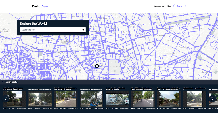
The focus of KartaView is road based imagery, much of which is from dashcam footage. This explains why it was of interest to Grab for an acquisition, as this type of data will be useful for their operations.
There are a two ways to upload imagery to KartaView:
Most dashcam footage uploaded to KartaView comes from people capturing images in their vehicles using their phones.
KartaView has a leaderboard of uploads, the top contributor at the time of writing, JB Brown, has uploaded 653,091.26k (or 97,407,587 points in KartaView) using an Android device(s).
Any image uploaded to KartaView is released under a CC-By-SA License by the owner and each image can be downloaded in the web app or API by any user.
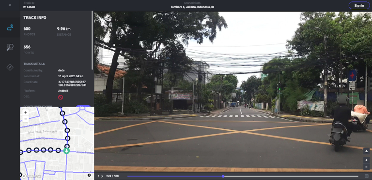
One of the neat features of KartaView I really like is the ability to recreate the journey by quickly navigating through the images in a sequence using the timeline (though no automatic playback is available).
Like Mapillary, KartaView has a good level of integration with OpenStreetMap to improve map data, including via their own OpenStreetCam JOSM plugin. When browsing images in the web app, you can use the OSM tab to jump into other editing tools too.
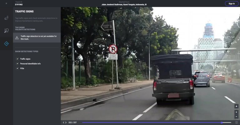
KartaView also runs three types of object detections on uploaded images:
- Traffic signs
- Personal identifiable info
- Points of interest (POI’s)
That said, I have not been able to get this to display on the UI, nor do I see detection data exposed via the KartaView API.
All of their codebase is open on GitHub, including the core app and mobile apps (Android and iOS), and are all offered under MIT licenses.
Update 2021-07-24: As @nickw pointed out on the forum, the latest commit of the core app only contains the front end. The old version (with backend included) is still available via commit history here.
I’m going to spend a few hours in the coming week exploring the KartaView codebase and the KartaView API. Check back next Friday when I should have a detailed technical write up of my findings.
Posted by:

David Greenwood, Trek View Chief Explorer
The latest treks in your inbox
Join our mailing list to be the first to know when new treks are published online.
Off-Road Street View

Explore trails from all over the world captured on foot, by bike, on skis, and using many other adventurous forms of transport. Fill in the gaps by requesting new coverage or capturing your own.
Similar Posts You Will Enjoy Reading...
Recommend
About Joyk
Aggregate valuable and interesting links.
Joyk means Joy of geeK