

Google Maps massively expands its mass transit crowd-reporting service
source link: https://arstechnica.com/gadgets/2021/07/google-maps-massively-expands-its-mass-transit-crowd-reporting-service/
Go to the source link to view the article. You can view the picture content, updated content and better typesetting reading experience. If the link is broken, please click the button below to view the snapshot at that time.
i'll wait for the next one —
Google Maps massively expands its mass transit crowd-reporting service
Google's mass transit crowd reporting will expand to 50x its current reach.
Jim Salter - 7/21/2021, 7:10 PM

Today, Google announced a major expansion of its ability to warn users of crowded mass transit ahead of time. The feature originally launched in June 2019 and covered roughly 200 cities globally, using user-reported data similar to Waze to discover and predict overcrowded trains and buses. Google is expanding that 200-city initial rollout to (eventually) over 10,000 transit agencies in 100 countries, according to today's announcement.
Unsurprisingly, Google Maps' mass transit predictions don't just rely on direct user-reported data. They utilize AI models trained on that data."We apply world-class anonymization technology and differential privacy techniques to Location History Data to make sure your data remains private and secure," the announcement declares—although we must point out that attempts to anonymize location data frequently fail.
-
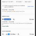
A user finds a bus line that will take them to a Google store in NYC. The app lets the user know that the bus is currently not crowded—and lets them change that status if the app got it wrong.
-
In New York City and in Sydney, users are treated to an additional level of granularity—the app predicts which individual cars on a given train are least crowded.
-
Google's Timeline Insights lets you be "mindful" of the time you spend commuting.
Google says its mass transit crowd reporting lets users know whether their transit line is likely to "have lots of open seats, hit full capacity, or be anywhere or in between," letting users make a more informed decision about whether to "hop on board or wait for another train." In New York and Sydney, the program is piloting even deeper information, offering live crowdedness information "right down to the transit car level." Today's announcement also notes that across the USA, mass transit is less crowded after morning rush hour and prior to evening rush hour—information unlikely to surprise anyone who uses mass transit regularly.
AdvertisementMaps is also upgrading its Timeline feature to include mass transit travel history, letting users know how much time they've spent and distance they've traveled via mass transit, walking, driving, and more. If you don't like that feature—or don't trust Google's "world-class anonymization technology"—you can disable your Android device's Location History entirely. (Disabling Location History will have a significant impact on ride-share, weather, and mapping apps, among others—and it may render some entirely unusable.)
Recommend
About Joyk
Aggregate valuable and interesting links.
Joyk means Joy of geeK